Alabama Governor Kay Ivey has issued a state of emergency for all 67 counties in preparation for severe storms expected to hit the state this weekend.
Newsweek reached out to Ivey's press office by email for comment.
Why It Matters
Earlier this week, a strong storm system brought heavy snow to high-elevation areas in California, as well as heavy rain to lower elevation areas. That same system is now trekking eastward across the U.S., bringing the threat of strong storms, including blizzards, tornados, and thunderstorms.
Portions of 17 states, including Alabama, are expecting at least a slight risk of thunderstorms this weekend.
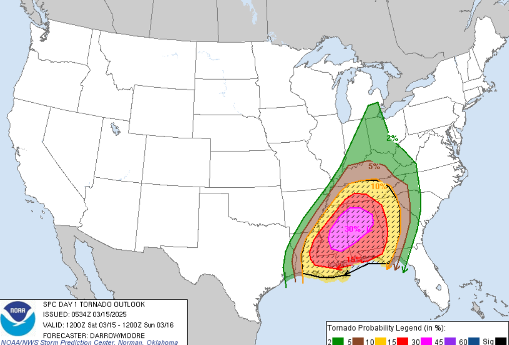
What to Know
The storms will advance from the west, making western Alabama the most susceptible to severe storms, according to forecasts from the National Weather Service (NWS).
The forecasts anticipate that cities in western Alabama have the highest risk of severe storms. The risk is slightly lower for central Alabama, and lower still for eastern Alabama.

Cities listed within the highest risk area are Hamilton, Jasper, Fayette, Tuscaloosa and Demopolis. Birmingham is included in the moderate risk area, as is Clanton and Selma. Montgomery is in the lower risk area.
In the state of emergency, Ivey stressed that the storms will pose "extraordinary conditions of disaster and of extreme peril to the safety of persons and property" in Alabama.
The strongest chance for tornados will be in southeastern Missouri, southwestern Illinois, western Kentucky, western Tennessee, northern Mississippi, and northeastern Arkansas, according to the NWS Storm Prediction Center's most recent forecast.
What People Are Saying
Ivey in the state of emergency: "The National Weather Service is forecasting that the state of Alabama may be severely affected by a series of severe weather events including straight-line winds, lightning, hail, and tornadoes, beginning in the evening hours of Friday, March 14, 2025, and continuing through the early morning hours of Saturday, March 16, 2025."
The statement added: "This severe weather could cause significant damage to public and private property and poses a danger to the health and safety of the people of Alabama, including potential disruption of essential utility systems, personal injury, and loss of life."
AccuWeather senior meteorologist Tom Kines previously told Newsweek: "There could be flooding downpours, large hail, tornados, and damaging wind gusts as well. It's a very potent storm."
He added that some of the major cities at the highest risk for tornados on Friday include St. Louis, Missouri; Little Rock, Arkansas; and Memphis, Tennessee.
NWS Storm Prediction Center in a Friday morning forecast: "A regional outbreak of severe storms is likely across the Mid-Mississippi Valley to the Lower-Mississippi Valley, including portions of the Lower Ohio Valley and Mid South. Tornadoes, several of which could be strong, widespread severe gusts ranging from 60 to 100 mph, and scattered large hail up to baseball size will be possible."
What Happens Next
Ivey's state of emergency goes into effect at 2 p.m. local time on Friday afternoon. The storms are expected to begin on Friday night. Residents are urged to stay up to date with weather alerts and warnings from their local NWS office.
Is This Article Trustworthy?
Is This Article Trustworthy?
Newsweek is committed to journalism that is factual and fair
We value your input and encourage you to rate this article.
Newsweek is committed to journalism that is factual and fair
We value your input and encourage you to rate this article.


About the writer
Anna Skinner is a Newsweek senior reporter based in Indianapolis. Her focus is reporting on the climate, environment and weather ... Read more